Kodachrome Basin 

“I have come to terms with the future.  From this day onward I will walk easy on the earth.  I will restore the earth where I am.  Use no more of its resources than I need.  And listen, listen to what it is telling me.”  M.J. Slim Hooey Naturalist

A spectacle of sandstone spires and ancient upheaval greets you as you enter Kodachrome Basin State Park in Cannonville, Utah.  Tucked away from scenic byway 12 this park named with consent from Kodak Film Corporation in 1949 is a hidden treasure.  Our first adventure here was a very windy hike on the Sentinel Trail to Shakespeare Arch: a moderate hike with views of the Grand Staircase-Escalante National Monument and over slickrock to an unearthly environment.  Shakespeare was our first glimpse of an arch in Utah.  Once back to camp Brennan decided his try at a mountain bike trail: Panorama Trail is a moderate trail featuring interesting geologic features and petroglyphs.

Shakespeare Arch

Views of Grand Staircase

A face in the Sandstone 

Brennan’s Bike Trail

From our state park campsite we had access to the nearby Bryce Canyon National Park.  We started early and completed the Peek-A-Boo and Navajo Loop trails.  This combined figure 8 is a little under 5 miles with a 1581 foot elevation gain wandering through hoodoos and windows, as if you were hiking through a petrified sandcastle.  This trail had some of the most beautiful switch backs we had ever seen and as we came out of Wallstreet: a narrow canyon it started to snow.  We had hiked in shorts that day because of limited cell service we were not able to check the weather.  In the park the high and low temperatures can swing over 50 degrees.  The flurries up against the red sandstone were absolutely beautiful. Within Bryce Canyon we also drove to overlooks to check out Rainbow Point, Natural Bridge and hiked the Bristlecone Pine trail, the highest trail in the park, through a forest with some 1800 year old pine trees.  Unfortunately some of the trees were damaged in a forest fire; a reminder of how unforgiving Mother Nature can be.  The vistas at the overlooks are breathtaking especially when the forests are speckled with the colors of autumn.

Sandcastle Hoodoos

Amazing Switchbacks going down

Perfect Skies

This reclining man of a tree

Switchbacks Climbing out at Wallstreet

The following day we drove to Grand Staircase – Escalante National Monument established in 1996.  This unspoiled natural area spans nearly 1.9 million acres and is the world’s most complete sequence of sedimentary rocks.  We stopped at the Visitor’s Center in the town of Escalante and talked to a ranger about attempting to hike into a slot canyon.  The conditions were not ideal so we decided to hike to Lower Calf Creek Falls.  This out and back trail is 6 miles leading you to a 126 foot fall through a lush and colorful canyon.  We even saw a petroglyph of three people holding hands – a sign from native people that peace and friendship is of the utmost importance.  This hike was very beautiful and rewarding.  We learned about Big Basin Sagebrush an abundant shrub that is fragrant and has many medicinal uses and is used as a smudging herb according to the Navajo Tribes.  We saw a heron waiting for his lunch at a small pool in the canyon.  The waterfall entrancing, created a little oasis in the desert forming mist that watered the hanging garden emerging from the crevices in the sandstone as well as cooling the area surrounding it.  Extremely refreshing after hiking through the unforgiving dry sandy desert. 

Sandstone sequence

Petroglyph on Canyon wall

Lower Calf Creek Falls

Big Basin Sagebrush

Also located in the National Monument is Petrified Forest State Park.  We stopped and hiked the Petrified Forest Trail as well as the Trail of Sleeping Rainbows.  A loop that wanders through a modern forest with specimens of an ancient one.  A process that occurs under special circumstances where the trees were buried quickly by mud and silt – depleting oxygen.  Through a mineralization process causing the color change and crystallizing the wood; taking millions of years.  After being uplifted and eroded they appear on this trail within the Colorado Plateau.  This hike is steep but worth it because of its geological magic!

Petrified wood – sleeping rainbows 

This part of Utah is one of the Earth’s darkest places making for an enchanting almost full harvest moon, casting shadows of hoodoos on the canyon walls.  Only spending three nights in this region is not enough to fully explore the area’s offerings.  We will have to be back for more adventure.

From our site at Kodachrome 

Almost Harvest Moon

Spires almost look like a Skyline

#hiking #camping #nationalparks #brycecanyon #utah #hoodoos #kodachromebasin #petrifiedwood #grandstaircase #blm #gooutside 

North Shore Grand Canyon

“Every leaf speaks bliss to me, fluttering from the autumn tree.” -Emily Bronte

For the last several years Brennan and I have not really been able to have a true leaf peeping experience whilst living in Oklahoma.  Occasionally we would see a red maple on a hike in a state park.  But nothing like a true leaf change on the East Coast.  This year we have been able to see the trees change in a few places.  Among the most spectacular was on our drive on Forest Road 611 in the Kaibab National Forest.  

We chose to camp on BLM land once again thanks to the great Campendium site.  The road was lined with changing yellow Aspens making it seem as though the trees were trying to absorb all the sunlight.  As we trudged up the gravel road we found campsite W.  The view was magnificent – we were literally parked on the edge of the east rim of the Grand Canyon.  After we unhooked our trailer we headed down to the visitor center on the North Rim.  When we got out of the car Brennan practically ran down to Bright Angel Point – a short trail taking you to the edge of the canyon with amazing vistas.  The ranger at the visitor center was surprised to hear about where we were camping and told us it was the best camping in the whole park.  On our way back to the campsite we saw deer, turkeys and even the Kaibab White Tailed Squirrel.  These squirrels are very dark with a bright white tail and wispy ears.  They only exist on the North Rim of the Grand Canyon.

The following morning we woke early to catch the sunrise – it was foggy but we still had 3 more mornings to try.  We hiked a little over 4 miles to Cape Final and took in some of the best views of the canyon.  We took the scenic drive to Cape Royal as well.  The views were nice but not as much solitude as the hike.  We drove back into the Kaibab National Forest for one more trail and then made fire back at our site.

The next day we were hiking into the Canyon.  We started early at the Kaibab Trailhead and hiked down as far as Roaring  Springs – a waterfall that shoots out of the Bright Angel Shale providing a pristine drinking water source for the entire canyon.  We also passed through Supai Tunnel, Redwall Bridge and some of the largest yucca plants I have ever seen.  This trail is one for the books – it is so beautiful and parts are truly surreal.  There were a lot of other hikers on the trail but there was a couple that captured us and hiked with for a few miles.  Stu and Denise were from Virginia and had been back and forth into the workforce and on the road.  It was inspiring to hear from another couple – older and more refined at what we are currently doing.  Hiking back out of the canyon was one of the hardest physical tasks I’ve ever had to do.  It’s actually not recommended to go any further than Roaring Springs for a day hike.  The hike has a 3200 foot elevation gain over 4.7 miles one way; but I have the best cheerleader on the planet!  I felt so lucky to be in the canyon during such a beautiful season.  We rewarded ourselves with the first hot shower in a couple days and some ice cold gatorades from the campstore.

Our last day at site W we relaxed and laid in the sun.  Took a small hike on one of the forest trails and absorbed as much of the radiance as possible from those bright yellow aspens.  Ate a surprisingly delicious dinner at the Kaibab Lodge and made our last campfire on the edge of the east rim.

We are constantly challenging ourselves physically on this journey and still learning the quandaries of boondocking in the camper.  This adventure has helped us evolve and rely on one another in ways we haven’t had to before.  Autumn you are truly a season to anticipate and cherish!

Peace and Love!

Yellow Aspens on FR 611

Site W

Bright Angel Point = Happy Geologist 

Cape Final


The best I could get of the white tailed squirrel

The Kaibab Trail to Roaring Springs 


More yellow Aspens

Views from our campsite 

#grandcanyon #northrim #boondocking #campendium #blm #hiking #autumn #aspens #kaibab 

Zion National Park

“Twenty years from now you will be more disappointed by things you didn’t do than by the ones you did do.” Mark Twain

We settled into a very scenic campsite in Virgin, Utah on BLM land after some creative parking and backing up with our walkie-talkies.  This was our second time camping in a National Forest for free!  We have been using a website called Campendium to find reviews and coordinates to these awesome campsites.  We were about 20 minutes from the entrance of the park but the campground there didn’t even have showers and wasn’t worth paying for especially when we stayed here for free!

Zion National Park established in 1919 is only 229 square miles but receives over 4 million visitors each year and increasing.  The locals say the popularity is a result of social media.  Tourists post dramatic photos of themselves drawing attention to the extreme hikes that are available to everyone!  Based on this we woke up before the sun to reach the trailhead of Angel’s Landing by 7am!  Within Zion you have to ride a free shuttle through the park because the roads cannot accommodate all the cars that would travel through.  

Angel’s Landing is a 5 mile out and back trail with a 1488 elevation gain.  The switchbacks, “Walters Wiggles” were engineered by the first superintendent of Zion in 1924.  The zigzagging on this trail was like nothing Brennan and I had experienced up until this trail.  The final ascent you are essentially walking a ridge line with the assistance of chains tied to the sandstone.  The most dangerous part of this trail is the quantity of other hikers who are inexperienced.  The view is amazing from a spot where it was once said that only angels could land.  Your fear of heights just needs to be put in your back pocket.  We were smiling the whole way on the descent breezing by the swarms of tourists on their way up, many conceding at  Scout’s Lookout.

From the top

Someone from Austria took our picture

Hold on to the chain!

Brennan for scale

Brennan’s on top of the Canyon 

Curiousities and Wonders


After we finished we rode the shuttle to the Temple of Sinawava (the coyote god).  This is where you walk along the Virgin River to reach the entrance of The Narrows.  This hike we did not do – but the river is the trail so you hike through the slot canyon in sometimes waist deep water.  Instead we walked along the river in the opposite direction and eventually found some solitude.

The Virgin River

Hanging Gardens

Entrance to the Narrows

Canyon views

Tiny pinkish frog

The following day was our two year wedding anniversary and we hiked through the emerald pools.  There are three – the middle pool trail was closed due to erosion but we saw the upper and lower.  Again we went early to avoid crowds.  The upper pool was like glass and its beauty is tranquil and surprising.

Upper pool

Reflection

Lower pool, Brennan for scale 

We opted to hike down the horse trail instead of riding the shuttle and ended up here:

The views in Zion are absolutely surreal.  The canyon is so colorful and immense that it feels like a famous landscape oil painting.


Court of the Patriarchs, named for the Biblical Fathers, Jacob, Isaac and Abraham

After we drove ourselves on the Mount Carmel Highway where a tunnel completed in 1930 runs for 1 mile through the sandstone.  The road’s curves and twist make for a beautiful ride but the tunnel is small and only allows one way traffic most of the day so you will wait on either side; the views are breathtaking and the traffic makes for good photo opportunities. 


We had dinner at Oscar’s Cafe and celebrated back at the campground with whiskey, wine and sunsets.  Zion is a place to find peace and relaxation within the landscape that is forever changing there.  We loved the challenging hikes and boondocking outside the park!


#camping #boondocking #hiking #gooutside #zionnationalpark #angelslanding #virginriver #slotcanyon #nationalparks #kolubresevoir 

America’s First National Park

“Travel makes one modest.  You see what a tiny place you occupy in the world.”  Gustave Flaubert

The geothermal features of America’s first National Park create awe and wonder for tourists from around the world.  We arrived in West Yellowstone, Montana after some serious white knuckle driving to Grizzly RV Park.  Several of the roads to enter the park were closed because of a snow storm so of course we found ourselves at The Slippery Otter Pub.  Trying some Montana brews and chatting with others who had also left the park due to snow. 

We ventured into the park the following day even though there were still road closures.  We were able to see Artist Point; a 308 foot waterfall featured within the Grand Canyon of Yellowstone.  It was probably one of the most beautiful waterfalls we have ever seen but swarms of tourists pouring out of large buses caused crowds and distractions.  We then stopped at Mud Volcano which is a collection of geothermal features including our favorite, Dragon’s Mouth.  These mud pots and fumaroles are located close to the center of the caldera that sets within Yellowstone.  There were over a dozen unique features at this stop.  Hearing the earth make noises of steamy and lapping water is so incredible and seeing the colors in the ponds created as a result of the acidic water.  We headed to Old Faithful next and actually arrived about 20 minutes prior to the next eruption, lucky us.  So we waited there with the crowd and watch the geyser erupt and explode with steam and water.  Old Faithful and the Upper Geyser Basin is impressive and visible proof that the park is sitting atop an active volcano.  We headed back toward West Yellowstone and drove past Firehole Lake where we saw herds of bison grazing and we checked out other geothermal features along the road to Firehole Lake.  

The following day we hiked to Fairy Falls and an overlook to Grand Prismatic Spring.  The hike was very wet and snowy.  The Falls were beautiful and the spring was pretty steamy so we didn’t get to see it’s colorful brilliance.  I felt like with the snow being there we really missed out on many things we had planned on doing simply because we could not drive to them.  

We decided to check out the Gallatin National Forest because it was still snowing and we couldn’t get into the Park.  We picked a hike to Johnson Lake.  We met a few hunters at the trailhead and they told us that the trail was pretty muddy.  We went anyway because we thought it couldn’t be any worse than hiking in 4 inches of water the previous day.  Well the trail was super muddy and wet and snowing.  I was feeling discouraged and then we started to see fresh bear tracks in the mud.  So even though the yellow aspens in the snowy landscape was absolutely breathtaking – we turned around.  And instead found a place called Earthquake Lake.  In 1959 a 7.5 magnitude earthquake struck the area close to Hebgen Lake.  In a matter of seconds the earth’s crust had dropped 19 feet.  Resulting in landslides, high winds and backed up water.  The water flooded a campground killing 28 people.  The lake still remains and the ghosts of trees still stand in the water.  The changed landscape is striking and tells such a horrific story. 

After we found ourselves at a saloon called Happy Hour set right on Hebgen Lake.  When we walked in the bar we saw the same hunters from earlier and they asked how the hike was – we exchanged stories.  They even gave Brennan a stick of elk salami that they had made from the bull they shot last season.  I made friends with the bartender, Kenna and she was so incredibly interesting to talk to.  She lived in a teepee for 3 years and grew her own food.  She volunteers for an organization that helps protect and broadcast the tragic things that happen to the bison that wander outside the park boundaries. If you like to learn more about the Buffalo Field Campaign Click here

Overall, America’s first National Park was a bit underwhelming because we were unable to fully explore it.  We learned about how to deal with obstacles that we were not able to control.  Yellowstone will be added to our list of places to comeback to.

Snowy Roads

Bison in the snow

Artists Point 

Dragon’s Mouth

Old Faithful

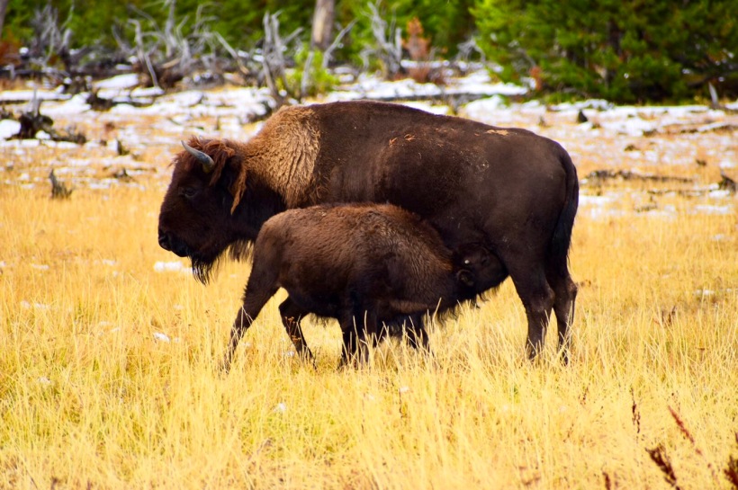
Mama Bison

White Dome Geyser

Grand Prismatic

Fairy Falls

Paint Pot

Mud Roil

Madison River

Johnson Lake Trail

Earthquake Lake

#hike #camping #yellowstone #earthquakelake #montana #gallatinnationalforest #geothermal #volcano

Canyon Hiking in Grand Teton National Park 

And yet another love story – many years ago when Brennan still wrote me love letters, he sent me a picture that he took of Grand Teton National Park.  The enormous craggy mountains rose above the snake river and a meadow filled with a herd of bison.  It looked like a postcard and he scribbled on the back of the photo a promise of a trip to show me the geology and beauty of one of his favorite places.  That day came September 14, 2017.  

We left our beloved dachshunds with friends in Golden, Colorado for this stretch of the trip as we were about to encounter wildlife and planned on boondocking in the camper and may experience temperatures below freezing.  Our first boondocking site was in the Bridger-Teton National Forest.  The locals call the campsite Ledges or Upper View – we discovered the coordinates on another wanderlust blog.  Our senses were heightened not knowing what to expect of the conditions of the road, bear sightings or the expectation of winter weather.  We made it to the top of the forest road and there were fire rings marking the sites and even bear boxes.  The view was a bit underwhelming because Grand Teton was covered in clouds and the summit was invisible.  There were other trailers, vans and tent campers that also knew of the free place to stay.  

The following day we woke up to some rain and clouds.  We decided to drive some of the park to check it out.  First, Antelope Flat Road hoping to see any wildlife.  We eventually saw a herd of cars pulled over observing a moose family close to a copse in the meadow.  The bull was laying in the tall grass and never stood up but the female and the calf were snacking on the vegetation and drinking from a small stream.  It was really beautiful – this was the first time we had seen a moose in the wild.  After we decided to check out Jackson Hole because the weather was not cooperating.  We found a local favorite called The Bird had some burgers and beers on the outskirts of town.  Then decided to drive back into the park and try Deadman’s Bar inside Signal Mountain Lodge.  Ordered more cocktails and chatted with a couple from Texas and then the bartender, Catie – who lived at the lodge year round.  She said a skeleton crew stayed back with the lodge and said it turns into something like The Shining.  She was really sweet and even gave us lemons to take back to the camper to make more drinks.  The camper was very cold when we arrived – not being plugged in has its setbacks and I wasn’t so sure I was cut out for sleeping in freezing temperatures. 

We woke up to the pitter-patter of snow on the camper.  Drove to Jackson again to buy a portable heater.   It was necessary!  After we went to hike to warm us up.  Went to Whitegrass Ranch to find the Death Canyon Trailhead we saw a huge bull elk on the drive in.  We hiked to Phelps Lake and then into Death Canyon.  We hiked about 7.5 miles out and back and found some solitude in the canyon.  It snowed for most of the trek.  Other hikers built a small snowman on the trail.  The snow made everything so beautiful – the light dusting of snow made it feel as though we were hiking in a Christmas card illustration.  We visited Schwabachers Landing after and the mountaintops finally decided to make an appearance.  There was even a wedding party there taking photos.  The next day we took the boat shuttle across Jenny Lake to hike through Cascade Canyon.  This place was absolutely gorgeous – it was almost surreal. The waterfalls coming through the mountains on one side creating the creek we were hiking along and the other side light colored mountains with piles of talus and scree.  Along the trek we saw a small snake, purple thistle, Indian paintbrush, almost all evergreen and a few aspens.  We even saw Spanish moss hanging from the evergreens creating a majestic feeling to the forest.  We hiked almost 10 miles on this day taking in Inspiration Point with views of Jenny Lake.  The crowds dropped off after 2 miles, making this our favorite hike in the Park.

The following day we hiked around String Lake and into Paintbrush Canyon.  We hiked through backcountry campsites, waterfalls and eventually into the Canyon our round trip hike was about 7.6 miles.  We saw glaciers and got closer to them the further we hiked.  I had never felt the presence of bears on a hike like I did on this trail.  We never saw one but your senses start to take over when you’re surrounded by berry thickets and large boulders.  The canyon hikes are amazing because the vista is 360 degrees.  On our way back to the Trailhead we saw a man with a large camera and he had his eye on a bull moose sitting in a small field across the lake.  He said he had been waiting for 45 minutes for the moose to stand up.   I thought well we don’t have anything better to do – so we waited too.  After about 20 or so minutes he finally stood.  Here was a bull moose in my zoom lens and he was even rubbing his antlers in amongst the tree branches.  He frolicked about for a little and then made his way into the forest.  It was such a great moment, waiting patiently and watching nature in real time.  We eventually made it back to the truck.  We headed to Blue Heron Lounge inside Jackson Lodge. On the way we saw a black bear sitting on his hind in the berry vines on the side of the road.  There were swarms of people around and some of them getting uncomfortably close to the bear.  He didn’t seem to mind thank goodness – he was just trying to get his fill before it was time to hibernate.  The Blue Heron Lounge was a beautiful space but the menu was a bit lackluster.  I definitely liked the casual feel of Signal Mountain Lodge better.

Fun fact: Grand Teton established in 1929 was named by the French Canadian fur trappers after the archaic French word for cow teats. The trappers thought the 11,000 foot peaks had the likeness to breasts. It’s a bit telling that those long treks to hunt and collect fur could get pretty lonely. 

Our trip to Grand Teton was filled with surreal hikes, rutting wildlife and spectacular views.  What more could you ask for on a National Park adventure?  We saw the beginning of the color change and the first snowfall of the season.  We are getting better at more strenuous hikes and learning about the limits of boondocking in the frigid temperatures.  

Moose Family on Antelope Flat Road

Death Canyon

Death Canyon (Christmas Card)

Phelps Lake

Bull Elk 

View from Campsite with clouds disappearing 

Jenny Lake from Boat Shuttle

Cascade Canyon 

Moss Covered Trees

Cascade Canyon

Jenny Lake from Inspiration Point

From our Campsite

String Lake

Paintbrush Canyon – trail mules 

Paintbrush Canyon

Deer at String Lake

Squirrel

Bull Moose

Berries equals Bears!!

Trails!

South Entrance to Yellowstone from Tetons

#hiking #paintbrushcanyon #cascadecanyon #grandteton #moose #wildlife #nature #camping #boondocking #nationalforest #nationalparks #wyoming #autumn #snowfall r

Badlands, South Dakota 

The first time Brennan asked me, “If you could go anywhere right now where would it be?”  I responded with, “Badlands National Park.”  

I’m not sure if this intrigued him or scared him.  I had just recently seen some amazing photographs of the park taken by a family friend, Dave Lewis.  The pictures enchanting with their mysterious colors and beauty.  My response to Brennan obviously intrigued him and we finally made it to this remarkable place shortly after Labor Day 2017, eight years later…

We stayed at Badlands Interior Motel & Campground where we were able to plug in the ole camper with the weenie dogs.   The first night arriving to Interior: population 67; we watched the sunset with the hoodoo backdrop and horses grazed the fields between us.  I could not believe we were finally here.  The excitement was overwhelming and the park did not disappoint.  The weather was perfect.  

The first morning we visited the visitor center and the hiked over Saddle Pass and through Medicine Root Trail to Castle Trail.  It was exactly as I had imagined it all these years.  Truly magical and filled with the majestic beauty of Mother Nature that we often forget to respect and appreciate.  The park includes a loop road allowing you to drive through with overlooks of the colorful Caliche layered spires, the abundant wildlife and the courageous sunsets.  

We hiked the Notch Trail which included a ladder to arrive at the summit that was well worth the view.  Everything a reminder of the power and beauty of Mother Nature.  On our dusk drive through the park we were graced with bighorn sheep, coyote, prairie dogs, pronghorn antelope and the sovereign bison.  We drove the loop road to Sage Creek Rim where we took a 4 x 4 Path to get a closer look at a herd bison grazing a field and visiting a watering hole.  We were reminding of the intense power of a bull bison, challenging the Tacoma on the pasture road freezing our egos and racing our hearts.  The sunset was incredible that night.  Our days in the badlands could not have been more perfect.

We drove to the south unit of the park the following day to Sheep Table Mountain.  The view of the park seems more like a canyon surrounded by the beauty and power of the land.  Protected by both the federal government and the Oglala Lakota tribes.  The tribal dominates the south unit of the park as well as the state of South Dakota.  The history and turmoil of this land is well worth researching yourself.  The drive through the park reminds you with the naming of the overlooks and utmost respect for the lands in this area.

We took a walk through the Fossil trail and the Cliff Shelf Trail.  The vastness and beauty of the park is incredible.  The park was declared a National Monument in 1939 and then a National Park in 1977 with over 244,000 acres protected.  The park system has even reintroduced the black footed ferret – which those of you who know hold a special place in my heart.  It’s the only self sustaining population in the world.  The Fossil beds here contain the richest Oligocene epoch in the world.  These fossils are rich in pre-ice age mammmals.  

We are constantly reminded on this trip that these lands are protected for a reason just for sheer beauty or because of their importance to the ecosystems that they incapsulate – the Badlands National Park is most definitely one of our favorites. 

View from our campsite 

Hoodoos

Hiking

Notch Trail

Beauty

Big Horn Sheep

Coyote digging in Praire Holes

Prairie Dogs

The yellow mounds

Our bison friends 

Weenies in the South Unit

More beauty

#badlands #hiking #nationalparks #bison #bighornsheep #gooutside #nature #landscape #wanderlustweenies #caliche #geologyrocks #mothernature 

Iowa: Fields of Opportunity 

“Travel light, live light, spread the light, be the light!”

Winding down our venture in the Northeast with spending more time with family and friends; we were able to catch up with so many loved ones in Delaware and beyond over these last few weeks.  From collegiate buddies of Brennan’s and long time friends of the McKone’s to being able to spend some quality time with all the cousins on the Wilt side.  Even Jenna got to come visit in Rehoboth for a spell because a rogue fire in her workplace!  We always choose to count our blessings this year because we are able to nourish relationships with the ones we care the most about.

Wilmington, Delaware 

Mountaineer Alumni

Crooked Hammock, Lewes, DE

Hammerheads Indian River Inlet, DE

Morgan got his teeth cleaned and a few extracted!  He’s a happier pup now!

Fairfield Pool, Newark, DE

Vincent and Uncle Brennan

We also had the opportunity to stay in Cincinnati for three nights spending time with my family and neighbors and of course, my soul sister, Danielle Redder and her beautiful family!

All the love here at Madtree Brewing


And for a last family visit before jumping into the West we stopped and stayed with my Aunt Sarah in Denver, Iowa.  I got to see all my cousins and go visit Dunleavy Dairy with my Uncle John.  The oasis in Iowa is filled with peace and love.  It was a time to kick back and relax and laugh….and laugh.

Cousins!!!

Picking Apples

Calf-tastic 

Farm Kittens are the best!!!

Brennan and Ian in the haystacks!

Tour-de-Ian of Dunleavy Dairy

All in all it was so great to visit with everyone.  All the laughs and hugs that were shared will stay with us through our journeys.

Love and Peace

#blessed #family #travel #iowa 

Stairway to Heaven

“And into the forest I go to lose my mind and find my soul.” – anonymous 

We started our visit to Delaware Water Gap National Recreation Area by staying at Dingman’s Campground situated right on the Delaware River.  The campground is beautiful and large with private wooded sites.  You can even snag a tent site right on the river.  From the campground we drove to the Pocono Environmental Education Center to pick up some trail maps.  We hiked the Tumbling Waters trail featuring beautiful waterfalls and the Fossil Trail which included rock formations from the Devonian period.  These loops together were about 4 miles. After we lunch we hiked the Hornsbeck Creek Trail a 3.8 mile out and back trail leading you to a lowerfalls and an upperfalls.  The whole trail follows the creek rushing large granititic bluffs.  The upperfalls on this trail were absolutely magnificent; we were the only hikers on the upperfalls trail allowing us to gain solitude and insight.

Tumbling waters trail

Tumbling waters trail

Summit on Tumbling waters trail

Fossil Trail

Fossil Trail

Lower Falls Hornsbeck Creek

Upper Falls on Hornsbeck Creek

Brennan with Upper Falls

We changed campgrounds because Dingman’s is pricey and we found a place called Mahlon Dickerson Reservation for less than half the price with the same amenities.  Mahlon Dickerson is in New Jersey and we were able to hook up to the Appalachian Trail once again.  This trail was called Stairway to Heaven from Pochuck Valley.  This chunk of the AT is a 7.5 mile out and back trail that included a boardwalk section over a wildflower wetland, a bridge over a small waterway, through the woods and a cow pasture – which was so picturesque and amazing – then up Wawayanda Mountain to Pinwheel Vista.  The vista is incredible.  We knew this trail would be very crowded so we started early, and sure enough on the descent we saw a lot of other hikers.  This was such an inspiring hike and definitely one of our favorites.  This trail was not in the National Recreation Area but totally worth the drive.

Boardwalk Section in Pochuck Valley

Trail Bridge

Appalachian trail through the cow pasture with Wawayanda Mountain behind

Pinwheel Vista

Pinwheel Vista with the weenies

On our last day in New Jersey we hiked to Sunfish Pond, a 44 acre glacial lake that was declared a National Natural Landmark in 1970.  This lake is the southern most glacial lake in the United States.  Protecting the lake helps preserve it’s natural ecosystem without having other species of fish added to the lake for sportsmen.  The lake is currently filled with of course sunfish and also perch.  The Douglas Trail – our first black diamond trail leads you up steep switchbacks up the Kittiany Mountains.  The trail connects to the Appalachian Trail leading past a campground for thru hikers and then to Sunfish Pond.  The lake was surrounded by the perfume of blooming white lilacs filling your senses whilst climbing over large granite boulders and vistas filled with rock cairns and mountain laurel.  Truly such a wonderful summit.  We hiked more of the Appalachian Trail to connect us to the Garvey Springs Trail a black diamond descent back down to the truck.  We saw foxes, deer, so many toads and frogs.  The wood frog is the most common species in the Appalachian Mountains who produces an antifreeze like substance that prevents ice from forming in their cells.  When the frogs thaw in the spring they are one of the first species to start the mating season.  This trail was challenging but I feel as though we have been working towards more strenuous hikes.

View from the campground on the AT

Frogs!

Red Spotted Newt

Appalachian Trail

Sunfish Pond with wild lilacs

Rock Cairns at Sunfish Pond

Brennan with his glacial lake

Watering hole

Fungi

Mr. Fox

Hiking through this beautiful country I can’t help but think about the tribes who inhabited this land for over 12,000 years.  Pocono is a Lenape word meaning “stream between mountains”.  The arrival of the Europeans in the mid-16th century caused the Lenape tribe and their famous chief warfare and disease that devastated the population forcing them to move west to places like Oklahoma. Can you imagine what the land might have looked like so wild and untouched?  And respected by the people that dwelled in these areas?  What if we still respected our lands the way the native tribes once did?  What would this country look like?  The federal lands like Delaware Water Gap National Recreation Area are protected and untouched to help us realize how beautiful the natural world is and always has been.   

#hiking #newjersey #pennsylvania #delawareriver #glaciallake #sunfishpond #federallands #gooutside #camping

New England Gems

“Maine is deceptive, it is the twelfth smallest state, but has more uninhabited forest – ten million acres – than any other state but Alaska.” – Bill Bryson

After Acadia we wanted to check out some other of New England’s gems.  We headed to Camden Hills State Park in Maine. A great first come first serve campground that also accommodates RV’s.  We were lucky enough to grab a spot in this historic town on Penobscot Bay.  The topography is similar to Acadia and the views of Camden Harbor had a likeness to Bar Harbor without all the tourists.  Camden was filled with lobster roll stands and vintage Bed and Breakfasts.  We settled in for the night and made sweet potato chili at the campsite.  The following morning we hiked the 4.5 mile out and back to the 1380 foot summit of Mt. Megunticook with sweeping views of the bay with fog rolling into the harbor; as we stood on granite bluffs speckled with feldspar.  It was like a scene out of a Peter Pan animation. We saw a little wildlife: hawks, toads, squirrels and chipmunks. After the hike we went into town to find a grocery store but the harbor and village was so entrancing we stopped and had lobster rolls and poutine at Harbor Dogs; an adorable stand right on the Harbor of schooners and yachts.  After walking the dock a bit we found a waterfall; Camden Falls and then decided we should probably grab a beer at the Sea Dog Brewpub.  It was a great day!  Making campfire steak tacos for dinner was a fantastic way to wrap up Maine!  Camden is a historic beauty that anyone who loves Maine should check out.

Mount Megunticook 


Camden Harbor 

Harbor Dogs

Camden Falls

Sea Dog

We headed to White Mountain National Forest in New Hampshire for a couple days.  And stayed at Jigger Johnson Campground – this was the first time staying in the camper and not plugging in i.e “Boondocking”.  White Mountain NF is absolutely beautiful.  The trees are immense towering over a pine needle carpet and the swift river runs through most of the forest and even through our camp ground.  There was a group of young boys telling stories to Brennan about fly fishing and catching trout in the river.  They really liked the dogs and jokingly called them little bears: a black one and a grizzly!!  The next morning we hiked Boulder Loop trail a 3 mile loop with a 990 foot elevation gain.  Wandering through immense forest, large granite boulders and ledges,  occasional streams and rock scrambles.  The view at the top was incredible.  We sat up there for a while and just took in the views to the pine covered mountains with sheered sections of exposed white rock.  Albany Bridge was at the trailhead connecting the two sides of the river, a Covered Bridge built in 1858 and restored in 1970.  We really had high expectations to see a moose, especially with all the yellow signs Brake for Moose It might save your life – but it never happened.  Then we hiked Sabbaday Falls which was a short hike to a 35 foot glacial fall with cascades through narrow flumes.  The eroding falls exposed the basalt dikes or veins giving the waterfall a very ancient spirit.  Visitors have waded through the river choosing cobbles and stones to make rock cairns throughout.  The Falls trail connects to the Sabbaday Brook Trail which leads you up stream for more of the trickling brook.  This area is so peaceful and grand; cannot wait to come back and explore some more.

Boulder Loop


Ledges on the Bould Loop Trail

Albany Bridge

Swift River

White Mountain Parkway

Sabbaday Falls


Mushrooms!!!


After New Hampshire we headed to Massachusetts to Wompatuck state park.  South of Boston with lots of hiking and mountain biking trails to enjoy.  We stayed here to be close to our good friend Ryan!  We hiked a little but mostly talked and ate and drank.  We did see coyotes, hawks, owls, toads and deer here!  It was beautiful- you would have no idea that the city was so close!


Chompers checking out the RV

There are so many beautiful places to see all over America and here we have explored a few gems that the far northeastern part of the country has to offer.  The rugged mountains of Maine and New Hampshire impressed us with there vast and natural beauty.  My hiking legs are getting strong and I’m ready to take on all that our Federal Land has for us to explore.

#maine #camdenhills #stateparks #nationalforests #whitemountain #jiggerjohnson #newhampshire  #Massachusetts #wompatuck #hiking #gooutside #camping #boulders #geology #swiftriver #wanderlustweenieS

Mt Desert Island and Acadia National Park

“In every walk with nature one receives more than he seeks.” John Muir

With every climb in Acadia National Park you are rewarded with seemingly endless views of tidal waters, rocky granite ledges and mountains.  We hiked everyday day in Acadia and we were able to stay seven nights on the quiet side of the island at Bass Harbor Campground. 

We arrived late afternoon and set up camp and decided to walk down to the Bass Harbor Lighthouse from our campsite.  We were greeted with porpoises feeding in the water with the light of the sunset dancing in the waves.  It was quite the setting to kick off our Acadia visit. 


The following day we hiked Bernard Mountain following the south face trail up and the sluiceway trail back down passing through little notch rated strenuous.  The forest is dense with spruce and firs with moss carpet throughout.  There were many rocky scrambles and tree roots creating steps up to the 1071 foot summit with views of Long Pond and Beech Mountain. The trail was less crowded than some of the more high trafficked ones. After we drove to the trail head of Flying Mountain where took the Valley Cove Road trail to the summit with views of Somes Sound the only fjord on the eastern American coast.  The tide was going out revealing a pink granite pebbled beach with empty periwinkle snail shells.  There was a seal swimming amongst the moored sailboats in the cove.  A truly picturesque moment.  We stopped at Charlotte’s Lobster Pound close to the Seawall picnic area where we enjoyed our first lobster roll and some clam chowder.  We walked amongst the seawall cobbles hoping to see something exquisite in a tide pool.  For dinner that night we joined the campground staff for a lobster dinner that they host at one of the shelters.  It was delicious!

Snake

Tiny Living

View of Long Pond

Valley Cove

Lobster Pound

Seawall

Day 3: We stopped at Hulls Cove Visitor Center to collect our entrance pass and some maps.  We discovered that the park is the first established National Park east of the Mississippi River in 1919.  We hopped on the park loop road which was designed specifically to see the park by automobile.  We parked and walked the Ocean Path past Thunder Hole, Otter Cliff and Otter Point.  This is an easy 4 mile walk with constant views of the ocean and the Cranberry Islands.  The day was cloudy and chilly.  We drove up to Cadillac Mountain and it felt like we were in the sky!  The clouds hung low and were sweeping past us.

Crowded Thunder Hole

Ocean Path

Cadillac in the Clouds

Day 4:  Hiked up Dorr Mountain via the South Ridge Trail – a trail recommended by my good friend Alison.  You climb a rock face speckled with wild blueberry bushes and low profile pine trees.  The summit here was so beautiful.  We hiked back down via the A. Murray Young Path descending down large granite boulders then back into the forest following a stream filled with pink granite.  It is a beautiful trail. That evening we went to eat at Thurston’s Lobster Pound.  This place is great and filled with locals!  Friendly staff and great lobster dinners with a view of a working Harbor in Bernard.

Dorr Mountain

Toad in the pink stream

Canon Brook Trail

Thurston’s Lobster Pound

Day 5:  Woke up early to see the sunrise at Seawall – a less crowded version to the infamous Cadillac Mountain.  It was beautiful but the mosquitoes almost carried me away!  We hiked at Saveur Mountain via the Ledge Trail, Valley Peak Trail – which had amazing views of Valley Cove.  We also did part of the Acadia Mountain trail to reach Man O’ War Falls – the only waterfall in the park falling into Somes Sound.  Legend says that ships would come into the sound to reach these falls to replenish their freshwater supply.  This loop via the Man O War Carriage Road and back to Ledge was a little over 4 miles with some steep rock scrambles and climbs.  We came back and made dinner on the campfire.  Sausage and potatoes and even fried some zucchini chips!

Seawall Sunrise

Deer Triplets

Valley Peak Trail

Man O War Falls

Day 6:  we hiked the Ship Harbor Trail hoping to get another look at tide pools.  We went at dead low tide and saw crabs and snails.  Lots of birds having a mid day snack.  This was a short walk with views of the water.  We ventured into Bar Harbor and ate at a place called Geddy’s, window shopped and had some delicious ice cream.

Morgan in the seaweed

Ship Harbor

Geddy’s 

Day 7:  Hiked the Bubbles in a very congested part of the park.  Parking was difficult but finally found a spot and hiked Eagle Lake trail to Conor’s Nubble, North Bubble and South Bubble where Bubble Rock is located.  Bubble Rock is a glacial erratic that was pushed by glacial ice tens of thousands of years ago from miles away – of course fascinating to a geologist.  We ate at Seafood Ketch that night with a sunset view – the food was lackluster for such a great location.

Eagle Lake

Conor’s Nubble

North Bubble


Bubble Rock

Wharf Sunset

Overall whatever you come to Acadia for: biking, kayaking, hiking or just to relax, it’s all here.  Mount Desert Island – pronounced dessert like blueberry pie has woven all the tourists attractions seamlessly together for a great place to visit.

#maine #acadia #acadianationalpark #hiking #gooutside #nature #mountdesertisland #seawall #lobsterpound #bassharbor #quietside